San Antonio Water System pumps from two different underground aquifers, the Edwards Aquifer and the Trinity Aquifer.
Edwards Aquifer
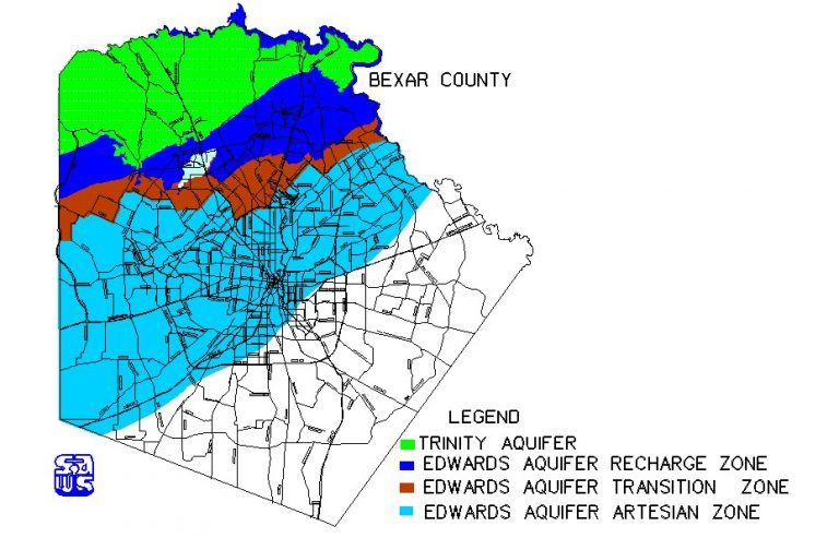
The Edwards Aquifer is intensely faulted and fractured carbonate limestone that lies within the Balcones fault zone. The dynamics and size of this geologic anomaly make it one of the most wondrous aquifers in the nation because of its storage capacity, flow characteristics, water producing capabilities and efficient recharging ability. The Edwards Aquifer and its catchment area in the San Antonio region is about 8,000 square miles and includes all or part of 13 counties in South Central Texas. The recharge and artesian areas of the Edwards Aquifer underlie the six counties south and east of the Balconces fault escarpment. The aquifer underlies approximately 3,600 square miles, is about 180 miles long from west to east and varies from 5 to 30 miles wide. The Edwards Aquifer receives most of its water from the drainage basins located on the Edwards Plateau. The catchment area, about 4,400 square miles, contains the drainage basins of the streams that recharge the Edwards Aquifer.
In the San Antonio region, the Edwards limestone attains a thickness of approximately 450 to 500 feet.
The water wells supplying SAWS customers number a total of 92 with an average daily pumpage of 136.50 million gallons per day or 418 acre-feet. From 1934 through 1994, the average annual recharge to the Edwards Aquifer was 676,600 acre-feet.
 |
Trinity Aquifer
Groundwater in northern Bexar County is produced from two primary aquifers, the Lower Glen Rose Limestone Aquifer and the Cow Creek Limestone Aquifer. These aquifers are part of the Trinity Aquifer group and are of Cretaceous age. The rock characteristic of the Lower Glen Rose is generally of shaley limestone to a silty dolomite. The Cow Creek formation is a fossiliferous dolomitic limestone with thinly bedded layers of sand and shale. The upper member of the Glen Rose formation is identified by its distinctive stair-step topography in northern Bexar County. It is not considered to be a significant water source due to its high mineral content. The recharge zone for the Lower Glen Rose and Cow Creek formations occur in Kendall and Comal County. The approximate thickness of the Lower Glen Rose Limestone is 300 feet and the Cow Creek Limestone ranges from 40 to 75 feet.